Home & Garden
Stanford Researchers Map Loss of Permafrost
Team pioneers new way to survey melting Arctic.
By Paul Gabrielsen
The arctic permafrost is thawing, and not just at the surface. The frozen terrain conceals regions of liquid groundwater containing the right mix of conditions to pose a new risk to the global climate. Now a Stanford-led team has demonstrated a new way to map these expanding liquid regions. Its findings are being published online this month in Geophysical Research Letters.
"These measurements go toward a better understanding of how permafrost thaw processes may impact future climate," said lead researcher and Stanford post-doctoral scholar Andrew Parsekian.
Find out what's happening in Palo Altowith free, real-time updates from Patch.
The term "permafrost," coined in 1943 by Stanford alum Siemon Muller, applies to ground that stays frozen all year long – approximately a quarter of the Northern Hemisphere. But low spots in permafrost terrain can fill with meltwater, forming small lakes. These lakes can melt the permafrost beneath them, forming a pocket of unfrozen soil called a "talik."
The melted talik contains plenty of organic material to feed hungry soil microbes, which generate methane as a byproduct of decomposition. Methane is a potent greenhouse gas, and scientists worry that methane released from Arctic permafrost could start an unstoppable feedback loop.
Find out what's happening in Palo Altowith free, real-time updates from Patch.
"This is a new carbon pool being turned on under climate warming," Parsekian said.
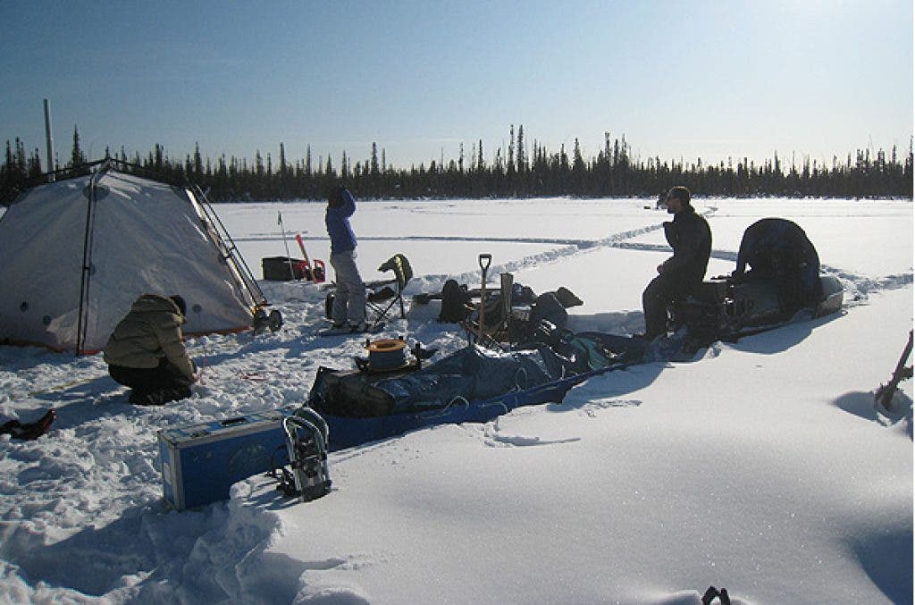
His team, comprising researchers from the U.S. Geological Survey, Rutgers University, University of Alaska Fairbanks, and Leibniz Institute for Applied Geophysics in Germany, used nuclear magnetic resonance, or NMR, to assess the extent of a talik beneath an Arctic lake. Camped on the frozen surface of Lake Caribou, near Fairbanks, Alaska, they set out loops of wire up to a football field in diameter, which created an electromagnetic pulse in the ground and water below. That pulse caused protons in talik water to wobble in a way Parsekian's team could detect.
NMR is the same technology used in a medical MRI, which uses magnets 10,000 times more powerful than a refrigerator magnet to perturb atoms. As those atoms return to their rest state, detectors pick up their unique resonance. Since those magnets, weighing several tons, are cumbersome to take into the field, Parsekian, a geophysicist, used the magnetic field of Earth as his magnet.
NMR is the only subsurface imaging method, he said, that is directly sensitive to unfrozen water content. The researchers checked the water and ice in nearby wells to confirm that the NMR measurements were providing accurate information about the situation underground.
Parsekian's team is the first to use NMR to detect taliks.
"By understanding that we have a really good method to make these measurements," Parsekian said, "we can scale it up into a larger regional study that will be able to change the way we think about Arctic permafrost."
Field conditions in Alaska were sometimes brutal. The team encountered temperatures as low as 40 degrees below zero, and used portable furnaces to keep their instruments from freezing.
Parsekian loves the adventure of working in Alaska. It's why he keeps going back. "It's a wild place," he said. "It's always exciting."
The team's work was funded by CUAHSI, NSF Hydrology Program, NASA Carbon Cycle Sciences and the U.S. Geological Survey.
Paul Gabrielsen is an intern at Stanford News Service.
Also on Palo Alto Patch
Stanford to Host Pan-Asian Music Festival during Lunar New Year
Lost Palo Alto Dog Reunited With Owner After Two Years
Steve Jobs’ Diet Lands Ashton Kutcher in the Hospital
Stanford Student Admits to E-stalking Boyfriend
Woodside Home Sells for $117.5 Million
Don't miss news that's important to you Subscribe to our daily newsletter.
|Like us on Facebook |Blog for us | Follow us on Twitter|

