Schools
Stanford's Underwater Robots Explore Deep-ocean Terrain
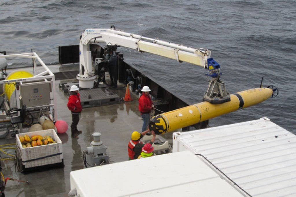
Engineers at Stanford's Department of Aeronautics and Astronautics and the Monterey Bay Aquarium Research Institute have developed autonomous underwater vehicles.
By Melissa Pandika
Underwater robots just got smarter. Engineers at Stanford and the Monterey Bay Aquarium Research Institute (MBARI) have developed a system that allows autonomous underwater vehicles (AUVs) to better anticipate obstacles in their path, enabling them to safely photograph even treacherous, distant reaches of the ocean floor.
Find out what's happening in Palo Altowith free, real-time updates from Patch.
Taking a series of photographs of the same areas over time helps scientists monitor the seabed for change. For instance, a conservation biologist might want to observe how species and habitats in marine protected areas are recovering from bottom trawling, a commercial fishing method that involves dragging a weighted net spanning hundreds of square feet along the ocean floor.
Noting changes in species and habitats can also help measure climate change.
Find out what's happening in Palo Altowith free, real-time updates from Patch.
Photographing the ocean floor with underwater vehicles isn't new, but the software system developed by Sarah Houts, a doctoral candidate in Stanford's Aerospace Robotics Laboratory, would for the first time allow vehicles to autonomously image twisting ravines and other hazardous topographical features.
Until now, scientists could image these tricky spaces only by remotely steering a vehicle themselves from aboard a ship, an expensive, impractical operation for missions involving periodic monitoring of the seabed. "It allows much greater flexibility," said Stephen Rock, the director of the Aerospace Robotics Laboratory.
Researchers from the aquarium research institute have recently developed AUVs that can image the ocean floor on their own, but only where it's relatively level. But Rock and other researchers believe that the most interesting science lies hidden in steeply dropping canyons and other interesting terrain.
"We need to be able to get into the interesting areas," Rock said.
Knowing what to do
To design a system that allows a torpedo-shaped vehicle to navigate remote, hazardous underwater sites, take photographs and return intact, Houts built on the terrain-relative navigation (TRN) system developed by Rock and MBARI engineer Rob McEwen. TRN allows a vehicle to know its location by matching its altitude (its distance above the ocean floor) to an existing terrain map. But to ensure that the vehicle would emerge unscathed, Houts had to give it the ability to anticipate and avoid obstacles.
Using the terrain map, Houts calculated the optimal trajectories, as well as the vehicle's optimal altitude, speed and orientation at each point along the flight path, allowing the AUV to safely fly close to the ocean floor. The autonomous craft applies algorithms to steer itself around obstructions in its path.
"We're saying, 'Now that I know where I am, this is what you want to be doing here. This is how high you want to be, this is the angle you want," Rock said.
The Stanford and MBARI engineers ran a successful field test with the new AUV system in Monterey Bay two weeks ago, during which they programmed the vehicle to fly over a cliff at a constant altitude to ensure that it understands the commands they give it.
In another test planned for early next month, they'll compare that flight path to the one the AUV takes when programmed with Houts' algorithms.
Rock expects his group to begin running missions with the new system by next year.
A 'tremendous shift'
Houts wants to adapt the anticipatory technology for a related project with MBARI to monitor icebergs for change. Similar to how the AUV would take photos of specific sites on the ocean floor, the vehicle in this project would collect samples from specific parts of an iceberg – with one extra challenge.
"The iceberg is moving through the ocean, so the vehicle needs to be able to also have an estimate of how the iceberg is moving so that it can stay with it and follow it around," Houts said. "Now your map is not stationary. It's moving through space. … The whole extra challenge of doing it around a moving object is really exciting." NASA's program on Astrobiology Science and Technology for Exploring Planets, which funds the project, wants to use similar technology with asteroids hurtling through the solar system.
The engineers hope to make their AUV system fully autonomous by next year. "The goal is to be able to do this without a map and just take measurements ahead of you in the terrain and fit a trajectory to that," Houts said. But the researchers would merge real-time measurements with a map for areas where one exists.
Rock said that his group's work is part of a "tremendous shift" from remotely operated vehicles to autonomous vehicles.
The transition occurring in underwater research programs parallels NASA's move away from the operation of planetary rovers by ground control stations. With computer processing more powerful than ever, engineers have a newfound capability to make fully autonomous missions a reality.
--Melissa Pandika is an intern with the Stanford News Service.
Also on Palo Alto Patch:
Stanford's touch-sensitive plastic skin heals itself
Kaiser Permanente Doctors Urge Flu Shots
Stanford Physicists Developing Quantum Cryptography
Stanford Scientists Build the First All-carbon Solar Cell
Don't miss news that's important to you Subscribe to our daily newsletter.
|Like us on Facebook |Blog for us | Follow us on Twitter|

